
Pakistan
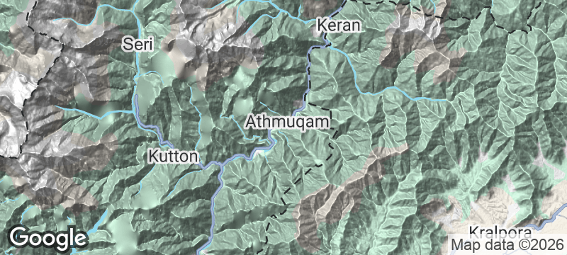
Neelum Valley
A valley split by a ceasefire line where the river flows freely between two warring nations.
The river runs jade-green through a gorge so narrow the forest canopy almost closes over it. On one bank, Pakistan. On the other, visible through the trees, the houses and paths of Indian-controlled Kashmir — close enough to hear a voice carry across the water, divided by a ceasefire line drawn in 1949.
Neelum Valley stretches 200 kilometres through Azad Kashmir in Pakistan, following the Neelum River from Muzaffarabad to the roadhead at Taobat. The valley is densely forested with pine and deodar, punctuated by waterfalls and roadside villages where Kashmiri chai — pink, creamy, and salted — is brewed in samovars and served to every passing traveller. At several points, the Indian side of the Line of Control is visible just metres across the river, making the political division physically tangible in a way that maps cannot convey. Keran and Sharda are the most accessible villages, each with guesthouses overlooking the water. The road ends deep in the mountains at Taobat, where the valley narrows to a gorge and trails continue into uninhabited high country.
Solo
The valley road unfolds slowly, each bend revealing a new waterfall or village. Solo travellers are absorbed into the rhythm of roadside chai stops and guesthouse conversations — Kashmiris treat a lone visitor as family.
Couple
Forested gorges, jade-green water, and the quiet seclusion of small guesthouses perched over the river. Neelum Valley offers mountain romance without the altitude demands of Gilgit-Baltistan.
- The Neelum River runs jade-green through a 200-kilometre valley lined with dense forest and dotted with waterfalls.
- Across the river, Indian-controlled Kashmir is visible — in some places only metres away — making the political reality physically tangible.
- Keran and Sharda are the most accessible of dozens of roadside villages, each with guesthouses overlooking the river.
- The road ends deep in the mountains at Taobat, where the valley narrows to a gorge and the trail continues into uninhabited territory.
Kashmiri chai — pink, creamy, and salted — brewed slowly in samovars.
Gushtaba — pounded lamb meatballs in yoghurt gravy, Kashmiri comfort food at its finest.
Fresh walnuts cracked from the shell at roadside stalls along the valley road.

Curral das Freiras
Portugal
A village hidden inside a volcanic crater so deep that nuns fled here from Atlantic pirates.

Látrabjarg
Iceland
Vertical sea cliffs swarming with puffins at the absolute western edge of Europe.

Imouzzer Ida Outanane
Morocco
A hidden waterfall in an argan forest where beekeepers harvest from wild cliff hives.

Aït Bouguemez Valley
Morocco
The Happy Valley — terraced barley fields and mud-brick villages sealed by winter snow.

Pir Ghaib
Pakistan
Cold green water pouring from bare limestone where no waterfall should exist in Balochistan's parched heart.

Moola Chotok
Pakistan
Turquoise pools cascade through a desert gorge where Balochistan's parched stone suddenly turns emerald.

Kund Malir
Pakistan
Golden sand meeting turquoise Arabian Sea with not a single structure from horizon to horizon.

Attabad Lake
Pakistan
Turquoise water filling a valley that was dry land until a 2010 landslide rewrote geography overnight.