
Chile
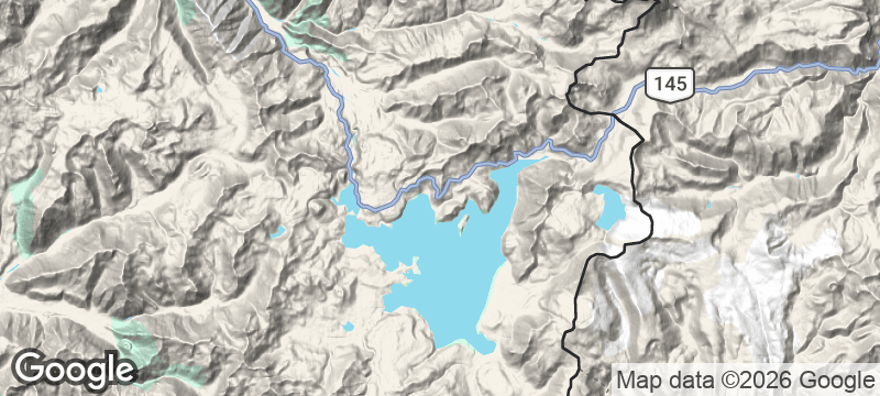
Laguna del Maule
Black lava flows frame a volcanic lagoon on the Argentine border, the earth still unsettled beneath.
Black lava flows run to the edge of cobalt water and stop, as if the earth couldn't decide whether to fill the basin with fire or ice. The wind at 2,200 metres is constant, pressing against you sideways, carrying no sound from any human source. The ground beneath your feet has shifted measurably since you started reading about this place.
Laguna del Maule is a volcanic lagoon in Chile's Maule Region, sitting at 2,200 metres in a depression on the Argentine border. The surrounding lava fields are from eruptions within the past 200 years, and the entire watershed is classified 'restless' by Chilean geological services — the ground deforms by several centimetres annually as subsurface magma shifts. A three-kilometre walking circuit passes lava tubes, pressure ridges, and spatter cones formed by different eruption events across different centuries. The lagoon is accessible only by 4WD on an unpaved forestry road that closes from June to November, concentrating all visits into five months.
Solo
Laguna del Maule is raw, geologically restless, and devoid of infrastructure. For the solo traveller drawn to landscapes that are actively in process, this is the earth reshaping itself in real time.
Couple
The five-month access window makes reaching Laguna del Maule feel like a secret. Share the drive up the forestry road, walk the lava circuit together, and descend to Maule Valley vineyards for the reward.
- The lagoon sits at 2,200 metres in a volcanic depression on the Argentine border, surrounded by lava fields from eruptions within the past 200 years.
- The entire watershed is classified 'restless' by Chilean geological services — the ground deforms measurably by several centimetres annually as the magma below shifts.
- A 3km walking circuit passes lava tubes, pressure ridges, and spatter cones formed by different eruption events across different centuries.
- The site is accessible only by 4WD on an unpaved forestry road that closes from June to November — the brevity of the access window concentrates visits into 5 months.
Pack provisions — there is nothing at the lagoon but wind, lava, and cobalt water.
Post-trip asado and Maule Valley wine at vineyard restaurants on the descent.
Vino pipeño from clay tinajas at roadside bodegas in the Maule Valley below.

Mount Sunday
New Zealand
A solitary hill standing guard over a braided river plain — Tolkien's Rohan made viscerally real.

Jebel Qamar
Oman
Frankincense valley terraces dropping into the Arabian Sea through clouds of monsoon mist.

Flatruet
Sweden
Sweden's highest road crossing a treeless plateau where musk oxen roam at visibility's edge.

Carnarvon Gorge
Australia
Aboriginal hand stencils pressed into sandstone walls deep inside a gorge of towering palms.

Reserva Costera Valdiviana
Chile
Valdivian temperate rainforest spills directly onto empty Pacific beaches where rivers meet surf.
Parque Nacional Bernardo O'Higgins
Chile
Chile's largest park, reachable only by boat, where glaciers calve into fjords no trail has reached.

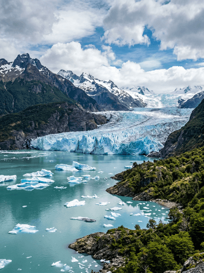
Glaciar Jorge Montt
Chile
A glacier retreating so fast the maps can't keep up, ice calving into a turquoise fjord.
Parque Nacional Alerce Andino
Chile
Three-thousand-year-old alerce trees rise from moss-draped Valdivian rainforest — South America's answer to sequoias.