
Chile
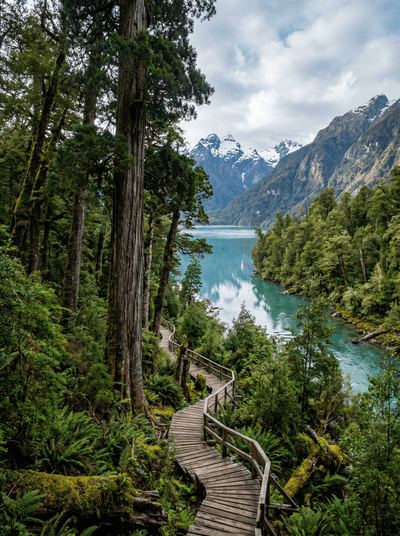
Glaciar Jorge Montt
A glacier retreating so fast the maps can't keep up, ice calving into a turquoise fjord.
The ice groans. Then a slab the size of a house separates from the glacier face and collapses into turquoise water, the shockwave rocking your kayak 500 metres away. Glaciar Jorge Montt in Chile's Aysén Region is retreating at roughly one kilometre per year — the fjord you paddle through did not exist on any map before 1990.
The glacier face stretches five kilometres wide and rises 60 metres above the waterline, but the submerged mass extends another 200 metres below — what you see is only a quarter of the whole. Reaching it requires a minimum two-day commitment from Caleta Tortel, four hours by boat through channels choked with recently calved icebergs, some large enough to roll and capsize a kayak. There is no infrastructure at the glacier itself — no dock, no building, no trail. The route changes with every visit as new ice enters the fjord and old passages close. Jorge Montt is one of the fastest-retreating tidewater glaciers in the Southern Hemisphere, a place that is literally disappearing while you watch it.
Solo
The commitment required — days of travel, no fixed schedule, total self-reliance — filters out casual visitors. Solo kayakers who reach the glacier face earn a solitude that feels planetary in scale.
Couple
Sharing mate with the boat captain as the glacier cracks and groans across the fjord creates a memory with no equivalent. The isolation amplifies everything — the sound, the scale, the knowledge that this ice will not be here next decade.
- Jorge Montt is retreating at roughly 1km per year — the fjord you kayak through simply did not exist on any map before 1990.
- The approach requires threading through recently calved icebergs by kayak, some large enough to capsize if they roll — the route changes every visit.
- The glacier face is 5km wide and 60 metres above water — the submerged portion extends another 200 metres below, making the visible mass only 25% of the whole.
- The nearest settlement is 4 hours by boat — this is a 2-day minimum commitment with no fixed schedule and no infrastructure at the glacier itself.
Expedition lunch eaten on deck as icebergs drift past — sandwiches never tasted this surreal.
Cholga seca (dried mussel) stew at Caleta Tortel before the boat journey.
Mate shared with the boat captain as the glacier groans and cracks across the fjord.

Ardnamurchan Point
Scotland
The last lighthouse before the Atlantic, standing on the British mainland's most westerly inch of rock.

Spurn Point
England
A three-mile sand spit so narrow the sea threatens to snap it in half.

Fajã d'Água
Cape Verde
Hairpin bends drop through bougainvillea clouds to a hidden bay beneath the island of flowers.

Wakatobi
Indonesia
Bajo sea nomads living in stilt houses above coral drop-offs in the Coral Triangle’s heart.
Parque Nacional Alerce Andino
Chile
Three-thousand-year-old alerce trees rise from moss-draped Valdivian rainforest — South America's answer to sequoias.

Laguna del Maule
Chile
Black lava flows frame a volcanic lagoon on the Argentine border, the earth still unsettled beneath.

Reserva Costera Valdiviana
Chile
Valdivian temperate rainforest spills directly onto empty Pacific beaches where rivers meet surf.

Chaitén
Chile
A town half-buried by volcanic mud in 2008, rebuilt beside the ghost forest it created.