
United States
Canyonlands
The Colorado and Green Rivers fracture the Earth into a labyrinth of mesas with no bottom.
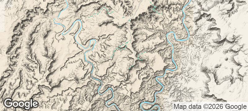
You stand at the edge of Island in the Sky and look down — not across, down — at the Colorado River threading a brown line through a maze of sandstone mesas 2,000 feet below. The scale is disorienting. There is no guardrail between you and the void, no soundtrack except wind, and no other park in the American West that makes you feel this small.
Canyonlands National Park in southeast Utah is divided into four districts by the confluence of the Colorado and Green Rivers, each district a different kind of remote. Island in the Sky, the most accessible, sits on a broad mesa with canyon-rim viewpoints reachable by short walks from paved roads. The Needles district, further south, offers backcountry hiking among sandstone spires and ancient granaries. The Maze — described by rangers as the most remote accessible point in the lower 48 — requires a 4WD vehicle, navigation by topographic map, and a permit. White Rim Road, a 100-mile loop carved into the canyon wall, takes three to four days by mountain bike or 4WD. In high-water years, Cataract Canyon's rapids generate flows exceeding 100,000 cubic feet per second, ranking it among the most powerful whitewater in the American West.
Solo
The Maze exists for solo travellers who want to disappear. Multi-day routes with no marked trails, no other people, and no mobile signal — Canyonlands rewards self-reliance with views no crowd will ever dilute.
Friends
White Rim Road by mountain bike is a multi-day expedition that demands teamwork and delivers canyon panoramas at every turn. The Cataract Canyon raft trip runs through the park's interior with rapids that turn a group into a crew.
- The Island in the Sky district sits on a mesa 2,000 feet above the canyon floor — the edge is a vertical drop with the Colorado River visible as a thin brown line below.
- The Maze district requires a 4WD vehicle, navigation by topographic map, and a permit — rangers describe it as the most remote accessible point in the lower 48 states.
- Cataract Canyon in the park's interior holds some of the most powerful whitewater in the American West, with flows exceeding 100,000 cubic feet per second in high-water years.
- White Rim Road — a 100-mile loop on a shelf road cut into the canyon wall — takes three to four days by mountain bike or 4WD and requires advance permits.
Campfire beans and cornbread cooked in a Dutch oven at a canyon-rim site.
Trail jerky and dried mango — the currency of the backcountry.
Cold beer earned at a Moab brewpub after days lost in the Maze.
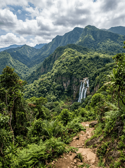
Udzungwa Mountains National Park
Tanzania
Waterfalls plunge through canopy so dense the forest floor never dries, sheltering primates found nowhere else.

Sary-Tash
Kyrgyzstan
A wind-battered crossroads at 3,200 metres where the road to China meets the road to Tajikistan.

Jebel Saghro
Morocco
Volcanic spires and mesa canyons where Aït Atta nomads still winter with their herds.

Mount Tambora
Indonesia
A seven-kilometre-wide crater left by the 1815 eruption that cancelled global summer.

Boundary Waters
United States
A thousand lakes connected by portage trails where motors are banned and wolves still howl.

Kodiak Island
United States
Brown bears taller than horses fishing salmon streams on an island bigger than Connecticut.

Channel Islands
United States
Five islands with no electricity, no shops, and foxes found nowhere else on Earth.

Katmai National Park
United States
Brown bears shoulder-deep in rapids, catching salmon mid-leap at the most primal scene in America.