
Kyrgyzstan
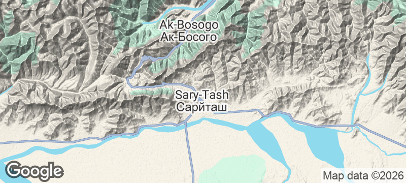
Sary-Tash
A wind-battered crossroads at 3,200 metres where the road to China meets the road to Tajikistan.
Wind hits the village from three directions at once, channelled by valleys that lead to three different countries. Sary-Tash sits at 3,200 metres in Kyrgyzstan's Osh province, a handful of buildings where the road to China's Irkeshtam Pass diverges from the route to Tajikistan's Kyzyl-Art Pass. The Trans-Alay Range fills the southern horizon — a wall of ice and rock that starts at seven thousand metres and offers no gentle introduction.
Sary-Tash is a crossroads village in the Alay Valley, positioned at the junction of two major border routes and the base approach to Peak Lenin (7,134 metres). Despite its tiny size, the village appears on every overlander's map because it is the last settlement with guesthouses before either border crossing. The Pamir Highway — the legendary M41 connecting Kyrgyzstan to Tajikistan — passes through here. The village's elevation and exposure make it one of the windiest inhabited places in Kyrgyzstan, with temperatures dropping below minus thirty in winter. For mountaineers and trekkers, Sary-Tash is the staging point for expeditions into the Trans-Alay Range. For overland travellers, it is the pause before a border that changes everything.
Solo
Sary-Tash attracts a particular breed of solo traveller — overland riders, long-distance cyclists, and trekkers who've been on the road for weeks. The guesthouses foster the kind of conversation that only happens between strangers who've chosen the hard route.
Friends
An expedition staging point works best with a team. Whether you are heading for Peak Lenin base camp or the Pamir Highway, Sary-Tash is where logistics become real and shared planning pays off.
- The village sits at 3,200 metres at the junction of the Irkeshtam road to China and the Pamir Highway road to Tajikistan.
- Lenin Peak (7,134m) is visible from the main street — the clearest road-accessible view of the mountain's southern face.
- The guesthouses host an unusual mix: mountaineers for base camp, cyclists crossing Asia, overlanders on the Pamir Highway.
- The wind is near-constant and strong enough to flatten tents — guesthouse stays are effectively mandatory.
Truck-stop lagman in one of two roadside cafes — the last hot meal before the border.
Thermos tea and dried fruit, standard fuel for overlanders heading to the Pamir Highway.

Walls of Jerusalem
Australia
An alpine plateau of pencil pines and glacial tarns named by trappers who found paradise.

Mount Robson
Canada
The Canadian Rockies' highest peak rarely reveals its summit — clouds guard it like a secret.

Big Bend
United States
Santa Elena Canyon walls rising fifteen hundred feet on either side of the Rio Grande.

Volcán Domuyo
Argentina
Patagonia's highest peak at 4,709 metres, surrounded by hot springs and geysers almost nobody visits.

Sary-Jaz Valley
Kyrgyzstan
A Soviet ghost town guards a valley of steppe and glacier rivers at the Chinese border.

Arabel Plateau
Kyrgyzstan
Treeless tundra at 3,800 metres dotted with fifty glacial lakes and retreating ice caps.

Enilchek
Kyrgyzstan
A Soviet mining town abandoned in the mountains — apartment blocks and cinema crumbling into tundra.

Kaji-Say
Kyrgyzstan
An abandoned uranium processing site above Issyk-Kul's south shore, Cold War ruins overlooking a holiday lake.