
Argentina
Cuesta de Miranda
Blood-red cliffs squeeze a single-lane road through 12 kilometres of hairpin vertigo.
The Cuesta de Miranda in La Rioja Province descends 12 kilometres of single-lane road through blood-red cliffs that press in from both sides, the switchbacks so tight that trucks cannot make the hairpins and must reverse to complete each turn, and the canyon walls above the road containing condors, peregrine falcons, and the occasional viscacha visible on ledges 200 metres above the tarmac. The road connects Chilecito in the Famatina Valley to Villa Unión in the Vinchina Valley and has no alternative — you either cross it or you go around by 200 kilometres.
The Cuesta de Miranda is a 12-kilometre mountain road in La Rioja Province descending 700 metres through the Miranda canyon, where the exposed geological sequence represents successive Precambrian, Ordovician, and Cretaceous formations in layers of red, violet, white, and grey. The canyon walls, rising to 300 metres above the road, are composed primarily of Ordovician metasediments stained by iron oxides — the same geological family as the Quebrada de Humahuaca and Talampaya formations, but produced by a different tectonic history. The Miranda river at the canyon base is the natural boundary between the Famatina Valley (vineyards, nuts, olives) and the Vinchina Valley (puna and volcanic terrain), and the drive through the Cuesta provides a compressed transition between two completely different Andean landscapes. The Condor Footprints rock art site near the canyon base contains pre-Columbian petroglyphs attributed to the Aguada culture (600-900 AD).
Solo
The Cuesta de Miranda rewards stopping at multiple points rather than driving through — the canyon wall geology changes character every few hundred metres, the condors nesting above the road are visible from specific pullouts that the locals know and visitors discover by accident, and the light on the red cliffs changes from ochre to crimson between noon and sunset.
Couple
The Cuesta de Miranda as part of the La Rioja circuit — Chilecito, the Miranda canyon, Villa Unión, and then north to the Talampaya-Ischigualasto corridor — covers the full range of La Rioja Province's geological and archaeological character in a two-day loop that almost no Argentine travel itinerary includes.
Friends
Groups cycling the Cuesta de Miranda (descending from Villa Unión to Chilecito, the easier direction) cover one of Argentina's most dramatic road descents at a speed that allows the canyon walls to be read rather than experienced as a blur. The road gradient is consistent and the views are immediate throughout.
- The fault gorge through the Famatina range has walls of iron-rich sandstone stained by 100 million years of oxidation.
- The road is single-lane with passing places — trucks and buses negotiate 20% grades in first gear.
- Condors nest in the highest faces and are routinely visible from the road without needing to stop.
- The western descent reaches Chilecito and its 1904 aerial tramway — the two sites combine naturally in a single day.
Chivito al asador and patero wine from Chilecito's bodegas artesanales at the road's western end.
Aceitunas riojanas and queso de cabra from roadside vendors near Villa Unión.

Jabal Aja
Saudi Arabia
Red granite peaks rising from the desert like frozen flames, hiding palm-filled valleys and rock pools.
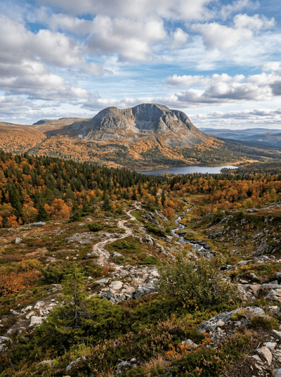
Sonfjället National Park
Sweden
A lone mountain where the only traffic is brown bears crossing between blueberry patches.

Akchour Waterfalls
Morocco
A Rif slot canyon where turquoise river water runs between moss-covered walls.

Phu Chi Fa
Thailand
A jagged cliff pointing directly at Laos across a tumbling ocean of morning clouds.

Dunas de Tatón
Argentina
Sand dunes rise over a thousand metres at the foot of the Andes where nobody goes.

Barreal
Argentina
A dried lakebed so flat and white it doubles as a land-sailing course beneath the Andes.

Parque Nacional Calilegua
Argentina
Cloud forest draped in moss where jaguars still prowl a jungle rising from the Chaco floor.

Salinas Grandes
Argentina
A salt flat so white it dissolves the horizon, cracking into hexagonal tiles beneath bare feet.