
Argentina
Quebrada de las Flechas
Tilted stone slabs pierce the earth like frozen arrows, an entire canyon turned sideways by time.
The Ruta 40 between Cafayate and Cachi runs through the Quebrada de las Flechas, 15 kilometres of red sandstone fins that rise vertically from the valley floor like the blades of a knife rack scaled for geography. The fins, up to 40 metres tall, have been tilted by tectonic pressure from horizontal bedding to near-vertical orientation — and their edges, weathered to points by 66 million years of erosion, are the 'arrows' (flechas) of the name. The road passes between and beneath them with no guardrails and nowhere flat enough to pull over comfortably.
The Quebrada de las Flechas in Salta Province was formed during the Cretaceous period when sedimentary rock beds were tilted by Andean uplift to angles approaching 90 degrees, then exposed by river erosion over millions of years. The red colouration comes from iron oxide in the Lecho Formation sandstone, and the varying resistance of different rock layers has produced a landscape of isolated fins, arches, and columns unlike anything else on the Ruta 40 corridor. The valley floor beneath the formation contains pre-Inca agricultural terracing and a creek lined with willows that provides the only shade in a landscape of total exposure. The ruins of the Angastaco winery, partly buried by rockfall, stand at the quebrada's northern end — a reminder that winemaking has been attempted at this altitude since the seventeenth century.
Solo
The solo traveller driving north from Cafayate toward Cachi encounters the flechas without expectation — nothing on the road signposts what is about to happen. The formation rewards a stop and a walk off the road, moving between the rock fins to understand their scale from inside rather than outside.
Couple
The Cafayate-to-Cachi drive, passing through the flechas, is one of the great Argentine road journeys — red rock, high desert, pre-Inca ruins, and small wine villages strung along a road with almost no traffic. Two people sharing it at their own pace is the correct way to do it.
- The tilted strata were folded and forced vertical by tectonic compression 60 million years ago.
- The arrow-like formations line both sides of Ruta 40 for 20km south of Angastaco.
- Sunrise hits the east-facing spires first — they glow orange for exactly 20 minutes before the angle softens.
- The approach from Cafayate passes through progressive shades of red rock before the flechas appear without warning.
Roadside empanadas from vendors along Ruta 40, filled with goat and potato.
Torrontés bought at a Cafayate bodega and drunk roadside as the sun drops behind the flechas.

Calhau
Cape Verde
A dead volcano rises from black sand beside a ghost village the Atlantic is slowly reclaiming.

Flatruet
Sweden
Sweden's highest road crossing a treeless plateau where musk oxen roam at visibility's edge.

Saint-Cirq-Lapopie
France
Cliffside houses dangling over the Lot where Breton stopped wanting to be elsewhere.

Mount Sunday
New Zealand
A solitary hill standing guard over a braided river plain — Tolkien's Rohan made viscerally real.
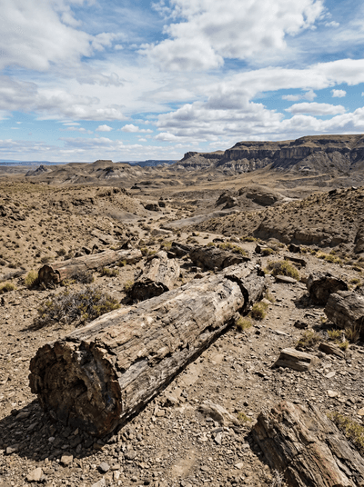
Bosques Petrificados de Jaramillo
Argentina
Trees turned to stone 150 million years ago lying where they fell across windswept Patagonian steppe.

Mar de Ansenuza
Argentina
South America's largest salt lake turns pink with thousands of flamingos each winter.

Bahía Bustamante
Argentina
A seaweed-harvesting hamlet turned private wildlife reserve where sea lions rest on beaches no one visits.

Parque Nacional Patagonia
Argentina
A cattle ranch returned to wilderness where pumas now stalk guanaco herds freely.